Manaslu Circuit Trek 16 days in 2026
The Manaslu Circuit Trek 16 days in 2026 is one of Nepal’s most breathtaking adventures, combining stunning mountain views with rich cultural encounters in the remote Manaslu region. Organized by Himalayan Dream Team, this trek begins in Kathmandu, a city filled with ancient UNESCO World Heritage Sites, and culminates with panoramic views of the majestic Mt. Manaslu (8,163 m), the eighth-highest mountain in the world. The route includes the iconic Larkya La Pass (5,106 m), one of the most dramatic passes in the Himalayas, making the journey both challenging and rewarding for those who seek adventure and authentic Himalayan beauty.

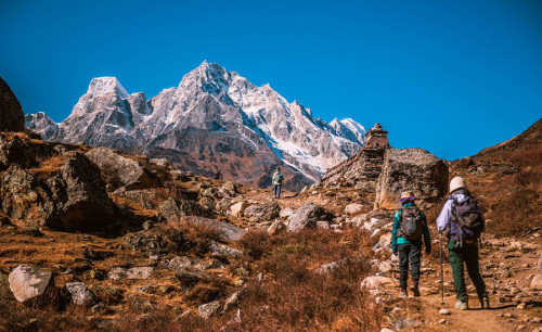
The Manaslu Circuit Trek itinerary is carefully designed for trekkers who love nature, culture, and adventure, and who possess a good level of physical endurance. It features well-planned acclimatization days and comfortable lodges to ensure safety and enjoyment at high altitudes. Trekkers will pass through lush green valleys, terraced farmlands, subtropical forests, and remote villages, gradually entering the high mountain landscapes where snow-covered peaks dominate the horizon. Along the trail, you’ll experience the spiritual charm of Buddhist monasteries, ancient Mani walls, prayer flags, and warm hospitality from the locals who still live according to centuries-old traditions.

One of the highlights of the journey is the opportunity to witness diverse ecosystems, from fertile lowlands to alpine meadows and glacial valleys. The Manaslu Circuit Trek distance is typically around 177 km, making it slightly longer and more adventurous than other classic trekking routes in Nepal. The trek offers a perfect balance of cultural immersion and natural beauty, with encounters in traditional Gurung and Tibetan-influenced villages, where life feels untouched by modernity.
The Manaslu Circuit Trek cost in 2026 is designed to provide great value, including all permits (such as the special restricted area permit), accommodations, and meals along the route. With the support of experienced guides and porters, you can trek with confidence knowing that logistics, safety, and comfort are fully managed. Carrying a Manaslu Circuit Trek map will help you appreciate the trail’s progression, from the lower valleys near Arughat and Soti Khola to the high alpine passes before descending into the Annapurna region.

This trek is ideal for travelers looking for a less-crowded alternative to Everest or Annapurna while still enjoying dramatic Himalayan scenery and cultural richness. Whether it’s the jaw-dropping views from Larkya La Pass, the untouched beauty of remote mountain villages, or the connection with the authentic Nepalese lifestyle, the Manaslu Circuit Trek is a once-in-a-lifetime journey. With its perfect blend of adventure, natural diversity, and cultural heritage, it is certain to leave a lasting impression on your heart and soul.
Manaslu Circuit Trek Trip Highlights:
- Begin with a sightseeing tour of the Kathmandu UNESCO world heritage sites
- Trek through the remote and less-crowded Manaslu region
- Follow the scenic Budhi Gandaki River with waterfalls and suspension bridges
- Enjoy stunning views of Mount Manaslu (8,163 m) and surrounding peaks
- Experience authentic Tibetan-influenced culture in Samagaun and mountain villages
- Visit ancient monasteries including Pungyen Gompa
- Acclimatization day in Samagaun with optional hikes to Manaslu Base Camp or Birendra Lake
- Stay in traditional tea houses and enjoy warm local hospitality
- Taste local food like dal bhat, momos, and Himalayan dishes
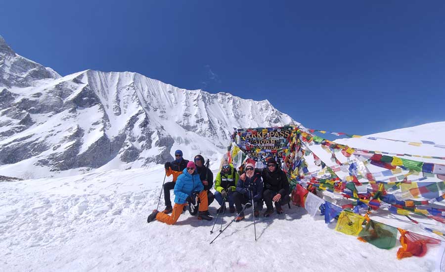
- Cross the dramatic Larkya La Pass (5,106 m)
- Walk through diverse landscapes from forests to high alpine terrain
Best Time to Trek the Manaslu Circuit
The Manaslu Circuit Trek can be enjoyed throughout much of the year, but spring and autumn offer the best weather, mountain views, and trekking conditions.
Autumn (September-November): Clear skies, stable weather, excellent visibility, and ideal conditions for crossing Larkya La Pass (5,106 m). This is the most popular trekking season in the Manaslu region, offering spectacular mountain panoramas and comfortable daytime temperatures.
Spring (March-May): Blooming rhododendron forests, colorful landscapes, active wildlife, and pleasant temperatures make spring one of the most beautiful times to trek. The clear mountain views and vibrant scenery create unforgettable trekking experiences.
Winter (December-February): Quiet trails and stunning snow-covered landscapes provide a unique Himalayan experience. Temperatures can be very cold at higher elevations, and snowfall may affect the crossing of Larkya La Pass. This season is recommended for experienced trekkers prepared for winter conditions.
Monsoon (June-August): The hills and valleys become lush and green, and the trails are quieter. However, heavy rainfall, muddy paths, leeches, and the risk of landslides make this the least recommended season for trekking the Manaslu Circuit.
For the best overall experience, we highly recommend trekking during April, May, October, and November, when weather conditions are generally at their most stable and the Himalayan views are truly spectacular.
Manaslu Circuit Trek Difficulty and Fitness Requirements
The Manaslu Circuit Trek is considered a moderate to challenging trek, suitable for trekkers with a good level of fitness. Most days involve 5 to 7 hours of walking through remote villages, forests, river valleys, and high-altitude mountain terrain.
The highest point of the trek is Larkya La Pass (5,106 m), where altitude can make trekking more demanding. While no technical climbing experience is required, proper acclimatization and preparation are essential.
We recommend training for 6 to 8 weeks before the trek with activities such as hiking, stair climbing, jogging, or cycling. With a well-planned itinerary and support from experienced guides, the Manaslu Circuit Trek is achievable for most healthy and active trekkers.
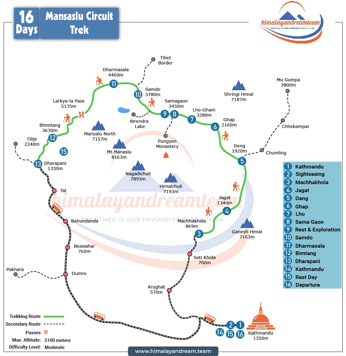
16 Days Manaslu Circuit Trek Itinerary
| Day | Program | Breakfast | Lunch | Dinner |
|---|
| 1 | Arrival in Kathmandu and transfer to hotel | X | X | ✔ |
| 2 | Sightseeing in Kathmandu Valley - UNESCO Heritage Sites | ✔ | X | X |
| 3 | Drive from Kathmandu to Machha Khola | ✔ | ✔ | ✔ |
| 4 | Trek from Machha Khola to Jagat | ✔ | ✔ | ✔ |
| 5 | Trek from Jagat to Deng | ✔ | ✔ | ✔ |
| 6 | Trek from Deng to Ghap | ✔ | ✔ | ✔ |
| 7 | Trek from Ghap to Lho | ✔ | ✔ | ✔ |
| 8 | Trek from Lho to Samagaun via Pungyen Gompa | ✔ | ✔ | ✔ |
| 9 | Rest day in Samagaun – Optional hike to Manaslu Base Camp | ✔ | ✔ | ✔ |
| 10 | Trek from Samagaun to Samdo | ✔ | ✔ | ✔ |
| 11 | Trek from Samdo to Dharamsala / Larkya Phedi | ✔ | ✔ | ✔ |
| 12 | Cross Larkya La Pass and trek to Bhimtang | ✔ | ✔ | ✔ |
| 13 | Trek from Bhimtang to Dharapani | ✔ | ✔ | ✔ |
| 14 | Drive from Dharapani to Kathmandu | ✔ | ✔ | X |
| 15 | Leisure day in Kathmandu | ✔ | X | X |
| 16 | Transfer to the international airport in Kathmandu | ✔ | X | X |
Manaslu Circuit Trek Permits and Regulations
The Manaslu Circuit Trek passes through one of Nepal's most remote and protected mountain regions. Because the trail enters a restricted area close to the Tibetan border, several government-issued permits are mandatory for all trekkers. Himalayan Dream Team will arrange all necessary permits before your trek begins.
Required Permits for Manaslu Circuit Trek
- Manaslu Restricted Area Permit (RAP)
- Manaslu Conservation Area Permit (MCAP)
- Annapurna Conservation Area Permit (ACAP)
Important Permit Information
The Manaslu region has special trekking regulations designed to protect its unique culture, environment, and local communities.
- Solo trekking is not permitted on the Manaslu Circuit.
- A minimum of two trekkers is required to obtain the Manaslu Restricted Area Permit.
- All trekkers must be accompanied by a licensed trekking guide.
- Permits must be arranged through a registered Nepali trekking agency.
- A valid passport copy and passport-sized photograph are required for permit processing.
- Permit checkpoints are located throughout the trekking route, so trekkers should always carry their permits during the journey.
With all permits and logistics arranged in advance by Himalayan Dream Team, you can focus on enjoying the spectacular Himalayan scenery, traditional mountain villages, Buddhist monasteries, and the unforgettable crossing of Larkya La Pass (5,106 m).
Teahouse Accommodation: What to Expect
During the Manaslu Circuit Trek, you’ll stay in simple but welcoming teahouses - small, family-run guesthouses that offer trekkers a warm bed, a hot meal, and a glimpse into Himalayan life. Although the facilities are basic, the atmosphere is cozy and authentic, providing a true mountain experience.
Rooms
Teahouse rooms are generally twin-shared, with wooden walls, thin mattresses, and warm blankets. Insulation is minimal, so a four-season sleeping bag is highly recommended, especially above 3,000 m. Rooms are tidy but simple - designed for rest after long trekking days.
Toilets and Showers
Most teahouses have shared toilets, typically squat-style, though some lower-altitude lodges offer Western toilets.
Hot showers are available at many stops for a small additional fee, often heated by gas or solar power. At higher altitudes, expect limited or cold water due to freezing temperatures.
Heating
Bedrooms are usually unheated, but the dining area becomes the heart of the teahouse in the evenings. A central stove burning wood or yak dung provides warmth as trekkers gather to eat, drink tea, and share stories - creating a communal and comforting environment.
Power and Wi-Fi
Electricity is available in most villages, but supply can be inconsistent. Charging phones or cameras typically incurs a small charge (especially at higher elevations).
Wi-Fi is available in some teahouses for a fee, though speeds are often slow or unreliable - a perfect excuse to disconnect and enjoy the mountain serenity.
Food and Drinks on the Manaslu Circuit Trek
Food and drinks on the Manaslu Circuit Trek are freshly prepared in local teahouses and provide the energy needed for long days of trekking in the Himalayas. While menus become simpler at higher elevations, trekkers can still enjoy a good variety of nutritious and satisfying meals throughout the journey.
Common meals and drinks available during the trek:
- Dal Bhat (rice, lentil soup, vegetables and pickles) – Nepal's most popular trekking meal.
- Noodles, fried rice, pasta, and potato dishes.
- Soups, porridge, pancakes, eggs, and Tibetan bread.
- Momos (Nepali dumplings) in many villages.
- Tea, coffee, hot chocolate, and ginger lemon honey tea.
- Vegetarian meals available throughout the trek.
- Vegan meals can often be arranged with advance notice.
- Fresh seasonal fruits may be served at some lodges.
- Safe boiled drinking water available for purchase in most teahouses.
Our recommendation: For the best health and energy at high altitude, choose freshly cooked local meals, stay well hydrated and avoid meat dishes at higher elevations where refrigeration is limited.
Altitude Sickness and Safety
Altitude sickness is one of the most important considerations on the Manaslu Circuit Trek, as the trail reaches a maximum elevation of 5,106 meters at Larkya La Pass. Some trekkers may experience mild symptoms such as headaches, loss of appetite, dizziness, fatigue, or difficulty sleeping as they gain altitude.
To minimize the risk, our itinerary includes a carefully planned acclimatization day in Samagaun, allowing your body sufficient time to adjust before moving higher. Our experienced guides closely monitor all participants throughout the trek and provide advice on hydration, pacing, and altitude awareness.
The best prevention is to walk slowly, stay well hydrated, eat regularly, and listen to your body. If any symptoms develop, it is important to inform your guide immediately so appropriate action can be taken.
Your safety is our highest priority. All Himalayan Dream Team guides are trained in first aid and altitude management. In the unlikely event of a serious medical emergency, helicopter evacuation can be arranged through your travel insurance provider.
With proper acclimatization, experienced guides, and a sensible trekking pace, the vast majority of trekkers complete the Manaslu Circuit safely and successfully while enjoying one of Nepal's most spectacular Himalayan adventures.
A Typical Trekking Day
- Wake up early and enjoy breakfast at the teahouse.
- Start trekking between 7:00 and 8:00 AM.
- Walk through villages, forests, rivers, and mountain landscapes.
- Stop for lunch at a teahouse along the trail.
- Continue trekking to the next overnight destination.
- Relax, explore the village, or enjoy mountain views upon arrival.
- Enjoy dinner with your group and guide.
- Receive a briefing for the next day's trek.
- Rest early and prepare for another day in the Himalayas.
Meeting the Team in Kathmandu
Pre-trip briefing with your Himalayan Dream Team guide: route review, safety & altitude plan, gear check, rental options in Thamel, dietary preferences, emergency procedures.
How Much Cash to Carry
After Arughat/Soti Khola there are no ATMs. Bring NPR 25,000–30,000 (USD 180–230) for Wi-Fi, charging, hot showers, snacks, drinks, tips, and small purchases. Carry small notes; keep dry/secure.
Cultural Etiquette and Responsible Trekking Tips for the Manaslu Circuit
The Manaslu region is home to traditional Tibetan-influenced communities, ancient monasteries, and sacred Buddhist sites. Respecting local customs helps preserve the region's unique culture and creates meaningful interactions with local people.
♦ Walk clockwise around stupas, prayer wheels, and Mani walls.
♦ Always ask permission before photographing local people, monks, or inside monasteries.
♦ Dress respectfully when visiting villages, temples, and gompas.
♦ Remove hats and shoes when entering monasteries or religious buildings where required.
♦ Support local communities by purchasing local products and services whenever possible.
♦ Help protect the fragile Himalayan environment by carrying out your rubbish & minimizing plastic waste.
♦ Use refillable water bottles and avoid single-use plastics along the trail.
♦ Respect local traditions, wildlife, and natural surroundings throughout your trek.
By trekking responsibly, you contribute to sustainable tourism and help preserve the cultural and natural heritage of the Manaslu region for future generations.
Tipping Guidelines Manaslu Circuit Trek (Nepal Trekking)
Tipping is a long-standing way to show appreciation for your trekking crew’s dedication and hard work. In Nepal, it’s not mandatory, but it’s a deeply appreciated gesture that recognizes the people who make your journey safe and memorable.
For the Manaslu Circuit Trek, the following tipping range is commonly practiced:
| Role | Suggested Tip (per day) | When to Give |
|---|
| Trekking Guide | USD 15 – 20 per day | At the end of the trek |
| Porter | USD 10 – 15 per day | At the end of the trek |
???? For a complete understanding of how, when, and how much to tip in Nepal’s trekking industry, read our full guide:
???? Tipping Culture in Nepal: How Much to Tip and When
Packing List for Manaslu Circuit Trek
Proper packing is important for a successful trek. Weather conditions can vary greatly between the lower valleys and the high mountains, so suitable clothing and equipment are essential.
???? For a complete, detailed gear guide with seasonal tips and brand recommendations, read our full article:
???? Complete Packing List for Manaslu Circuit Trek (2026)