

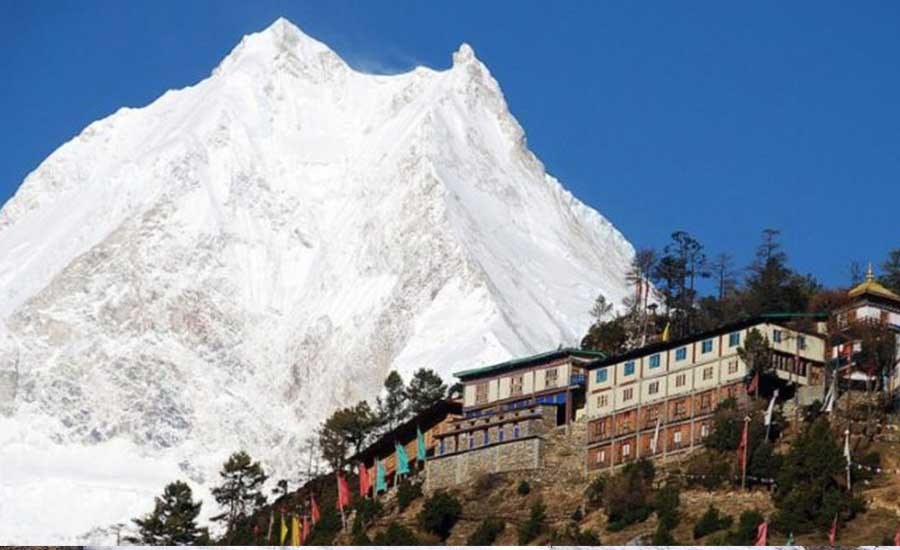
Manaslu Conservation Area is a spectacular protected region in northern Gorkha District, Nepal, known for Mount Manaslu (8,163 m), the Budhi Gandaki Valley, remote Himalayan villages, rich wildlife and Tibetan Buddhist heritage. Covering approximately 1,663 km², it includes the culturally distinctive Nubri, Kutang and Tsum regions. From subtropical river valleys to alpine meadows, glaciers and high passes, the landscapes change dramatically as you climb.
The area's most famous journey is the Manaslu Circuit Trek, crossing Larkya La Pass. The Tsum Valley Trek focuses on monasteries and traditional mountain communities, while the Manaslu and Tsum Valley Trek combines both experiences. This guide covers the conservation area itself, its natural and cultural attractions, permits, travel logistics, safety and Manaslu trekking conditions in every month of the year.
Manaslu Conservation Area: Quick Facts
| Topic | Details |
|---|---|
| Location | Northern Gorkha District, Gandaki Province, Nepal, near the Tibetan border |
| Established | 1998 |
| Area | Approximately 1,663 km² |
| Conservation management | National Trust for Nature Conservation (NTNC), through the Manaslu Conservation Area Project (MCAP) |
| Highest peak | Mount Manaslu, 8,163 m |
| Important valleys | Budhi Gandaki, Nubri, Kutang and Tsum |
| Common trek access | Road from Kathmandu towards Machha Khola, followed by walking towards Jagat |
| Most popular trek | Manaslu Circuit via Samagaun, Samdo and Larkya La |
| Best general trekking periods | March–May and late September–November, subject to actual conditions |
| Conservation permit | MCAP; additional restricted-area permits are needed on designated routes |
Where Is Manaslu Conservation Area Located?
Manaslu Conservation Area lies in the Himalayan north of Gorkha District. Its lower valleys follow the Budhi Gandaki River through steep gorges, terraced fields, suspension bridges and forests. Higher up, the settlements of Lho, Shyala, Samagaun and Samdo open onto the immense Manaslu massif. A branch route leads northeast into the culturally distinctive Tsum Valley. The area's remote position helps explain both its ecological diversity and the persistence of distinctive local traditions.
The main Manaslu Circuit generally enters the conservation area around Jagat and eventually crosses Larkya La to Bimthang, continuing towards Dharapani in the Annapurna region. Tsum Valley itineraries usually branch off near Lokpa and return by the Budhi Gandaki corridor.
History and the Manaslu Conservation Area Project (MCAP)
The conservation area was declared in 1998. Its management approach links wildlife and habitat protection with the needs of residents, conservation education and responsible tourism. NTNC's Manaslu Conservation Area Project works with local communities on natural-resource management, biodiversity conservation and sustainable development.
The abbreviation MCAP can mean either the conservation project or, in trekking conversations, the Manaslu Conservation Area Permit. They are not the same thing. The project manages conservation activities; the permit authorizes visitor entry to the conservation area.
Official background: NTNC Manaslu Conservation Area Project.
Landscapes, Mountains and Glaciers
Budhi Gandaki Valley
The lower route is shaped by the Budhi Gandaki River, with narrow gorges, bridges, waterfalls, farmland and villages. The approach provides a gradual introduction to the region's changing elevation and cultures.
Nubri Valley and Mount Manaslu
Higher settlements such as Lho, Shyala, Samagaun and Samdo provide dramatic views of the Manaslu Himal. Mount Manaslu rises to 8,163 m, making it the world's eighth-highest mountain. Nearby peaks include Himalchuli and Ngadi Chuli. Mountain views depend on weather and the exact viewpoint.
Tsum Valley
Tsum Valley is known for traditional Buddhist villages, cultivated fields, stone-walled paths, monasteries and views towards the Ganesh Himal. Its main appeal is a combination of cultural exploration and mountain scenery rather than crossing Larkya La.
Alpine Terrain and Larkya La
The Manaslu Circuit climbs above the tree line to rocky, glacial terrain. Larkya La is a demanding high pass, often quoted at approximately 5,106–5,160 m depending on the map or measurement used. Snow, wind and ice can make it hazardous even during popular trekking months.
Wildlife and Biodiversity in Manaslu Conservation Area
Manaslu's broad elevation range supports varied habitats: subtropical vegetation in lower valleys, temperate forests, rhododendron and conifer woodland, subalpine scrub and alpine grasslands. Its wildlife includes the elusive snow leopard, Himalayan tahr, musk deer and blue sheep, as well as numerous mountain and forest birds. These animals are wild and often difficult to spot; a trekking holiday is not a guaranteed wildlife-viewing safari.
Birdwatchers may encounter pheasants, raptors and forest birds depending on the season and habitat. Observe wildlife from a distance, do not feed animals, and never disturb nesting or denning sites. For conservation information and reported biodiversity inventories, refer to NTNC.
Local Communities, Culture and Monasteries
The region is home to communities with different languages and traditions. Nubri and Tsum have strong Tibetan Buddhist cultural connections, reflected in monasteries, mani walls, prayer wheels, chortens and village festivals. Local livelihoods include agriculture, livestock raising, trade and trekking-related work. Visitors should remember that these are living communities, not open-air museums.
Important Religious and Cultural Sites
- Ribung Gompa, Lho: a monastery in a beautiful setting with views towards Manaslu.
- Pungyen Gompa: a possible excursion from the Samagaun area when conditions and acclimatization permit.
- Mu Gompa: a major destination in Upper Tsum Valley, around 3,700 m.
- Rachen Gompa: an important Buddhist nunnery in Tsum Valley.
- Milarepa's Cave (Piren Phu): a sacred site associated with the Tibetan Buddhist teacher Milarepa.
- Gumba Lungdang: a remote nunnery with views towards the Ganesh Himal.
Ask before taking photographs of people or religious interiors, dress modestly and follow your guide's advice about local customs.
Best Treks in Manaslu Conservation Area
1. Manaslu Circuit Trek
The Manaslu Circuit Trek follows the Budhi Gandaki Valley through Jagat, Deng, Namrung, Lho, Samagaun and Samdo before crossing Larkya La and descending towards Bimthang. It combines Himalayan scenery, Buddhist culture, forests and an exciting high-pass crossing. It is best suited to fit travelers comfortable with consecutive trekking days and significant altitude.
2. Tsum Valley Trek
The Tsum Valley Trek explores the culturally rich northeast branch of the region, with villages such as Chumling, Chhokang Paro and Nile and religious sites including Mu Gompa. It avoids the Larkya La crossing but remains a remote multi-day trek with substantial walking and altitude.
3. Manaslu and Tsum Valley Trek
The Manaslu and Tsum Valley Trek combines both routes, allowing more time for the monasteries and villages of Tsum before rejoining the Manaslu Circuit. It is a longer and more demanding choice for travelers with sufficient time.
| Route | Main attraction | Key consideration |
|---|---|---|
| Manaslu Circuit | Mount Manaslu, Nubri villages, Larkya La | High pass and altitude |
| Tsum Valley | Monasteries, Tsumba culture, remote villages | Long walks and limited facilities |
| Manaslu + Tsum | Both cultural valley and high-pass circuit | More days and greater endurance |
Best Time to Trek in Manaslu Conservation Area
Spring (March–May) and autumn (late September–November) are generally the most favorable trekking periods. Spring brings warming conditions and flowering vegetation at suitable elevations; autumn often offers clear views after the monsoon. However, no month guarantees safe weather, pass access or uninterrupted road travel.
Summer monsoon (June–August) brings heavy rain to lower valleys, with muddy trails, landslide risk and transport disruptions. Winter (December–February) can bring deep snow and extreme cold in the upper valley, making Larkya La difficult or impossible. Tsum Valley and the Manaslu Circuit should be assessed separately because their highest points and route conditions differ.
Manaslu Trekking Month by Month: January to December
Wondering whether to trek Manaslu in January, April, October or December? The following guide explains the typical seasonal pattern for the Manaslu Circuit Trek and Tsum Valley Trek. Conditions vary greatly by altitude and from year to year, so this is planning guidance, not a forecast for any specific 2027 departure.
| Month | Typical conditions | Manaslu Circuit suitability |
|---|---|---|
| January | Very cold; possible deep snow and ice at higher elevations | Usually unsuitable for a standard Larkya La crossing |
| February | Still winter; snow and frozen trails may persist | High risk of pass closure; assess individually |
| March | Spring begins; warmer lower valleys, lingering high snow | Possible later in the month if pass conditions allow |
| April | Generally favorable spring weather; cold at altitude | One of the preferred months |
| May | Warmer; more clouds and pre-monsoon showers possible | Often good, especially earlier in the month |
| June | Monsoon onset; rain and landslide risk increases | Less recommended |
| July | Heavy monsoon rain in lower valleys; slippery trails | Generally not recommended |
| August | Continued monsoon, swollen rivers and possible road damage | Generally not recommended |
| September | Monsoon gradually withdraws; early-month rain can persist | Improves later in the month |
| October | Often clear and relatively stable; colder higher up | One of the most popular months, but not risk-free |
| November | Often dry and clear; increasingly cold, especially late month | Often good early to mid-month, weather permitting |
| December | Winter cold and increasing snow/ice risk | High pass becomes increasingly uncertain |
Manaslu Trek in January
January is one of the coldest months in the Manaslu region. Lower villages may remain accessible, but upper settlements, mountain lodges and Larkya La can be affected by deep snow, ice and freezing temperatures. A standard Manaslu Circuit crossing is generally not recommended. Limited lower-altitude cultural walks may be possible with current local advice.
Manaslu Trek in February
February remains a winter trekking month. Conditions may improve in lower valleys, but snow can persist on shaded slopes and the high pass. Travelers should not assume that an itinerary crossing Larkya La is feasible. Tsum Valley access also requires checking snow, trail and lodge conditions.
Manaslu Trek in March
March marks the transition towards spring. Lower trails begin to warm, while upper sections can remain cold and snowy. Late March may be suitable for some Manaslu Circuit departures if recent snowfall and pass conditions are favorable. Trekkers should carry proper cold-weather equipment and allow flexibility.
Manaslu Trek in April
April is one of the best months for the Manaslu Circuit Trek. Many trekking days have pleasant daytime temperatures in lower and middle elevations, and rhododendrons may bloom in suitable forest areas. High-altitude nights remain cold, and snow is still possible around Larkya La. April also suits many Tsum Valley itineraries.
Manaslu Trek in May
May generally offers warmer conditions, particularly in the lower valleys. Early May can be excellent for trekking, while cloud buildup, afternoon showers and pre-monsoon weather become more likely later in the month. Hydration, sun protection and attention to the latest forecast remain important.
Manaslu Trek in June
June is the transition into the summer monsoon. Rainfall can make lower paths slippery and increase landslide risk, while cloud and poor visibility may obscure the mountains. It is not a preferred month for the standard Manaslu Circuit, even if some higher sections remain relatively dry on particular days.
Manaslu Trek in July
July is generally a poor choice for the Manaslu Circuit or Tsum Valley. Heavy rain can affect roads, trails, river crossings and slopes. Landslides, swollen streams and leeches in lower forested areas can complicate travel. Consider a different season unless there is a compelling reason and current conditions are favorable.
Manaslu Trek in August
August continues the monsoon pattern, with possible prolonged rainfall, transport disruption and damaged trails. Even if a particular day looks clear, accumulated rainfall can destabilize slopes. Most travelers should plan their Manaslu trek for later in autumn rather than August.
Manaslu Trek in September
September is a transitional month. The first part may still bring monsoon rain, while later weeks often become more favorable as skies clear. Early autumn itineraries should pay particular attention to road, bridge and trail reports following the rainy season. Late September can be attractive if access has been confirmed.
Manaslu Trek in October
October is traditionally one of the most popular months for trekking in Manaslu. Post-monsoon skies often provide excellent mountain views, and daytime walking conditions can be comfortable. However, severe rainfall, flooding or landslides can still occur unexpectedly. In particular, any departures after a damaging weather event must depend on verified trail, bridge and road accessibility—not the calendar alone.
Manaslu Trek in November
November often brings clear skies and relatively dry weather, making it another popular trekking month. Temperatures drop sharply as winter approaches, especially in Samdo, Dharamsala and around Larkya La. Early November is usually more comfortable than late November, although actual snowfall can change the situation quickly.
Manaslu Trek in December
December marks the beginning of more severe winter conditions. Some lower routes may remain accessible, but higher villages can be very cold and the Larkya La crossing may become unsafe because of snow and ice. Lodge availability can also be limited. A full winter circuit should only be considered after a careful, current feasibility assessment.
Which Month Is Best for the Manaslu Circuit Trek?
For most travelers, April, October and early November are strong choices. May and late September can also be rewarding. March requires more attention to lingering snow, while June through August and the coldest winter months generally involve greater risks. The best individual departure depends on recent weather, trail condition, fitness and available time.
Which Month Is Best for the Tsum Valley Trek?
April–May and October–November are generally excellent periods for Tsum Valley's villages, monasteries and mountain scenery. Because the standard Tsum Valley Trek does not cross Larkya La, its conditions differ from the Manaslu Circuit, but winter snow and monsoon landslides can still disrupt travel. Higher optional excursions require separate assessment.
Manaslu Trekking Weather and Temperatures
There is no single temperature that represents the entire Manaslu region. A warm day in the lower Budhi Gandaki Valley may coincide with freezing temperatures at Samdo or Dharamsala. Weather also changes rapidly with wind, cloud cover, snowfall and elevation. Rather than relying on a single monthly average, pack for the coldest overnight altitude on your route and check updated forecasts before crossing high terrain.
Spring and autumn trekkers still need thermal layers, a warm insulated jacket, gloves, a hat, a windproof outer layer and a suitable sleeping bag. In winter or after snowfall, additional equipment and route changes may be necessary.
Manaslu Conservation Area Permit and Restricted Area Permits
Foreign trekkers generally need the Manaslu Conservation Area Permit (MCAP) and, for designated restricted trekking routes, the relevant Restricted Area Permit (RAP). The Manaslu Circuit normally also enters the Annapurna Conservation Area after Larkya La, so ACAP is generally required. Tsum Valley has its own restricted-area permit conditions.
| Permit | Published fee / requirement |
|---|---|
| MCAP (most non-SAARC foreign visitors) | NPR 3,000 per person |
| MCAP (SAARC nationals) | NPR 1,000 per person |
| Manaslu RAP: September–November | USD 100 for first 7 days; USD 15 for each additional day |
| Manaslu RAP: December–August | USD 75 for first 7 days; USD 10 for each additional day |
| Tsum Valley RAP: September–November | USD 40 for first 7 days; USD 7 for each additional day |
| Tsum Valley RAP: December–August | USD 30 for first 7 days; USD 7 for each additional day |
| ACAP | Generally NPR 3,000 for most non-SAARC foreign visitors when the itinerary enters the Annapurna Conservation Area |
Important: These are published fee references for planning, not a guarantee of 2027 rates. Rules, nationality categories, age exemptions, TIMS applicability and solo-traveler procedures should be checked before issuing a final quotation. Restricted-area trekking requires authorized arrangements and a licensed guide; permission for an individual traveler does not mean independent unguided trekking is allowed.
Official sources: NTNC conservation permits and Nepal Department of Immigration restricted-area permit fees.
How to Reach Manaslu Conservation Area
Most travelers drive from Kathmandu towards the Gorkha region and the Budhi Gandaki Valley, commonly reaching Machha Khola when roads permit. The trek then continues towards Jagat. Road travel may be slow, rough or interrupted by landslides, particularly during and after the monsoon. The return from the Manaslu Circuit typically follows the road from Dharapani after descending from Bimthang; Tsum Valley treks generally retrace the Budhi Gandaki approach.
Driving times and starting points can change with road construction and weather. Confirm the current route before departure and allow buffer time before international flights.
Accommodation, Meals and Drinking Water
Established trekking routes have locally run teahouses and lodges. Expect basic twin rooms, shared bathrooms in many villages, communal dining rooms and limited heating. Electricity, hot showers, charging and Wi-Fi may cost extra or be unavailable at higher elevations. Some lodges close seasonally.
Common meals include dal bhat, vegetable curries, potatoes, noodles, soups, Tibetan bread, porridge and tea. Vegetarian options are widely available, but dietary needs should be discussed in advance. Drink boiled, properly filtered or treated water rather than untreated stream or tap water.
Altitude Sickness, Safety and Insurance
The Manaslu Circuit climbs above 5,000 m, and altitude sickness can affect even experienced, fit trekkers. A sensible itinerary includes gradual ascent and acclimatization time around Samagaun and/or Samdo. Symptoms such as headache, nausea, dizziness and unusual fatigue should be reported promptly. Do not ascend to sleep higher while experiencing symptoms of altitude sickness; severe symptoms require urgent medical assessment and descent when feasible.
Choose travel insurance that explicitly covers the highest planned trekking altitude, emergency medical care and evacuation. Helicopter evacuation is subject to weather and availability and cannot be guaranteed. For further preparation, read our Manaslu Circuit Trek Safety Guide.
Essential Packing List for Manaslu
- Broken-in trekking boots, trekking socks and comfortable walking trousers.
- Thermal base layers, fleece, warm insulated jacket and waterproof/windproof shell.
- Warm hat, gloves, sun hat, sunglasses and high-SPF sunscreen.
- Season-appropriate sleeping bag and a comfortable daypack.
- Headlamp, reusable water bottles, water-treatment method and power bank.
- Personal medicines, basic first-aid supplies and travel insurance details.
- Trekking poles, cash in Nepalese rupees and copies of required documents.
For snow or ice, follow your licensed guide's assessment of any additional equipment. A packing list does not replace a current safety evaluation of Larkya La.
Responsible Travel and Conservation
Manaslu's environment is fragile and its villages are living communities. Use reusable bottles, carry out non-biodegradable rubbish, avoid disturbing wildlife, stay on established paths and respect religious sites. Ask permission before photographing people or monastery interiors. Support locally owned teahouses and fair working conditions for guides and porters. Do not fly drones without the necessary permits.
Frequently Asked Questions About Manaslu Conservation Area
1. What is Manaslu Conservation Area?
It is a protected Himalayan region in northern Gorkha District, established to conserve biodiversity and cultural heritage while supporting local communities.
2. Is Manaslu Conservation Area a national park?
No. It is a conservation area managed through a conservation and community-development approach.
3. How large is the conservation area?
Approximately 1,663 square kilometres.
4. What is MCAP?
MCAP may refer to the Manaslu Conservation Area Project or the Manaslu Conservation Area Permit. The project and visitor permit are different.
5. What wildlife lives in Manaslu?
Habitats support species such as snow leopard, Himalayan tahr, musk deer and blue sheep, although sightings are rare and never guaranteed.
6. What is the best month for Manaslu Circuit Trek?
April and October are popular choices, with early November and parts of May and late September also often suitable, depending on conditions.
7. Can I trek Manaslu in March?
Sometimes, especially later in March, but lingering snow around Larkya La may affect access.
8. Is April good for Manaslu trekking?
Yes. April is generally among the preferred months, although the high pass can still receive snow.
9. Can I trek Manaslu in May?
Often yes, particularly earlier in the month. Later May may bring increasing clouds and pre-monsoon rain.
10. Is Manaslu trekking possible in June, July or August?
Some travel may be possible, but monsoon rainfall, landslides, slippery paths and transport disruption make these months generally less suitable.
11. Is September a good time?
Late September is often better than early September, when monsoon conditions may persist.
12. Is October always safe for trekking?
No. October often has favorable weather but serious storms, floods and landslides remain possible. Current trail and bridge conditions must be checked.
13. Is November good for Manaslu trekking?
Often yes, especially earlier in the month, but cold and snow risk increase towards winter.
14. Can I cross Larkya La in December or January?
It may be unsafe or impossible because of snow, ice and extreme cold. Never assume the pass is open without reliable local assessment.
15. Is Tsum Valley easier than Manaslu Circuit?
The standard Tsum Valley route avoids Larkya La, but it still requires fitness, multiple trekking days and preparation for remote conditions.
16. Do I need a permit for Manaslu?
Yes. MCAP is required, and restricted-area permits apply to designated routes. ACAP is generally required for the standard circuit's exit into the Annapurna region.
17. Can a solo traveler book Manaslu?
Individual travelers can inquire about guided private arrangements, subject to the current permit rules. Restricted-area trekking is not independently unguided.
18. Do I need a licensed guide?
Yes, for the standard restricted-area trekking routes.
19. Are lodges available?
Yes, on established routes, but facilities are basic and seasonal closures are possible.
20. Is there mobile coverage or an ATM?
Coverage is patchy and reliable ATMs should not be expected on the remote route. Carry sufficient cash and plan for limited connectivity.
21. Do I need insurance?
Comprehensive insurance with suitable trekking-altitude, emergency medical and evacuation cover is strongly recommended.
22. Can the Manaslu trek be customized?
Yes. Himalayan Dream Team can arrange private guided itineraries based on time, fitness and interests, subject to permits and trail conditions.
Why Trek with Himalayan Dream Team?
Himalayan Dream Team Treks & Tours Pvt. Ltd. is a Kathmandu-based, women-led travel company arranging guided trekking and cultural journeys in Nepal. We can help with route planning, licensed guides, permits, transport, mountain accommodation and realistic acclimatization schedules. We also advise on current access conditions rather than assuming that a popular trekking month guarantees an open trail.
Explore our Manaslu Circuit Trek, Tsum Valley Trek and Manaslu and Tsum Valley Trek, or contact our team to discuss a private journey.
Final Thoughts: Exploring Manaslu Conservation Area in 2027
Manaslu Conservation Area is more than a trekking destination. Its mountains, forests, wildlife, monasteries and communities make it one of Nepal's most rewarding places for travelers interested in both nature and culture. Choosing the right month is important, but so is choosing the right route: the high-pass Manaslu Circuit and the monastery-focused Tsum Valley offer different experiences.
For most trekkers, spring and autumn provide the strongest starting point for planning. Check current permit rules, trail conditions and weather before confirming your journey, and travel with experienced local support.
Himalayan Dream Team Treks & Tours Pvt. Ltd.
Kathmandu, Nepal
www.himalayandream.team