

Manang Nepal Travel Guide: Altitude, Things to Do, Best Time & Annapurna Circuit
Manang, Nepal is one of the most fascinating high-altitude destinations in the Himalayas and one of the most important stops on the legendary Annapurna Circuit Trek. Surrounded by the towering peaks of the Annapurna range, glaciers, high mountain lakes, ancient Buddhist monasteries and the dramatic landscapes of the upper Marsyangdi Valley, Manang offers much more than a place to spend the night.
Located at approximately 3,540 metres (11,614 ft) above sea level, Manang is widely used as the main acclimatization stop on the Annapurna Circuit before trekkers continue toward Yak Kharka, Thorong Phedi and the challenging Thorong La Pass (5,416 m). Spending extra time here allows the body to adjust to the altitude while giving travellers an opportunity to discover Gangapurna Lake, Gangapurna Glacier, Ice Lake, Braga Monastery, traditional villages and Tibetan-influenced Himalayan culture.
But Manang is not only for trekkers crossing Thorong La. Improved road access has made the valley increasingly accessible to travellers interested in Himalayan scenery, culture, photography and high-altitude road journeys.
This complete Manang Nepal Travel Guide by Himalayan Dream Team covers everything you need to know: Manang's altitude, location, history, culture, weather, best time to visit, accommodation, food, road access, trekking routes, acclimatization, altitude sickness, things to do, Ice Lake, Gangapurna Lake, Braga, Tilicho Lake, Thorong La, permits and how to travel from Kathmandu to Manang.
Manang Nepal at a Glance
| Destination | Manang, Nepal |
| Location | Manang District, Gandaki Province |
| Region | Annapurna Region |
| Altitude | Approximately 3,540 m / 11,614 ft |
| Valley | Upper Marsyangdi Valley |
| Conservation Area | Annapurna Conservation Area |
| Famous For | Annapurna Circuit, acclimatization, Gangapurna Lake, Ice Lake, Buddhist culture and Himalayan scenery |
| Major Trek | Annapurna Circuit Trek |
| Major Pass Ahead | Thorong La – 5,416 m |
| Major Side Trip | Tilicho Lake – approximately 4,919 m |
| Popular Day Hikes | Gangapurna Lake, Chongkor Viewpoint, Praken Gompa and Ice Lake |
| Typical Stay | At least 2 nights on an Annapurna Circuit itinerary |
| Best Trekking Seasons | Spring and autumn |
Where Is Manang in Nepal?
Manang lies in north-central Nepal in the upper valley of the Marsyangdi River, on the northern side of the Annapurna massif. It forms part of Manang District in Gandaki Province and lies within the Annapurna Conservation Area.
The village occupies a broad high-altitude valley surrounded by spectacular Himalayan peaks, dry hillsides, glaciers and traditional settlements.
On the classic Annapurna Circuit, Manang lies after Pisang, Ghyaru, Ngawal and Braga and before the route continues toward Yak Kharka, Thorong Phedi, High Camp and Thorong La.
A typical progression is:
Besisahar → Dharapani → Chame → Pisang → Ngawal/Braga → Manang → Yak Kharka → Thorong Phedi → Thorong La → Muktinath → Jomsom
Is Manang a Village or a District?
The word Manang can refer to both Manang District and the famous settlement generally known as Manang village.
Manang District contains numerous settlements, valleys, trekking routes and high Himalayan landscapes. Manang village itself is one of the best-known settlements because of its strategic position on the Annapurna Circuit.
When trekkers say they are having a “rest day in Manang,” they usually mean Manang village and the surrounding area.
Manang Altitude: How High Is Manang?
Manang village is generally described as lying at approximately 3,540 metres (11,614 ft) above sea level. Different maps and sources may show slightly different elevations, commonly around 3,519–3,540 metres.
At this altitude, oxygen availability is significantly lower than at sea level. For this reason, Manang is an important place to slow down, observe how your body is adapting and spend an additional night before climbing higher.
Altitude is one of the most important reasons Manang plays such a central role in a properly designed Annapurna Circuit Trek itinerary.
Why Is Manang Famous?
Manang is famous for several reasons:
- It is the principal acclimatization stop on the Annapurna Circuit.
- It offers extraordinary views of the Annapurna Himalayas.
- Gangapurna Lake and Gangapurna Glacier lie close to the village.
- Ice Lake provides one of the region's most rewarding high-altitude day hikes.
- Nearby Braga is home to an important historic Buddhist monastery.
- Manang is an important gateway toward Tilicho Lake.
- It is the final major settlement before the high-altitude approach to Thorong La.
- The surrounding valley preserves a distinctive Himalayan Buddhist culture.
- Its dry mountain landscape contrasts dramatically with Nepal's greener lower valleys.
Manang: Gateway to the High Himalayas of the Annapurna Circuit
For most trekkers, reaching Manang marks a major transition on the Annapurna Circuit.
The lower stages of the trek pass through subtropical valleys, forests and agricultural villages. As the route climbs through Chame and Pisang toward Manang, the environment gradually becomes drier, colder and more distinctly Himalayan.
After Manang, the landscape becomes increasingly sparse as the route climbs toward Yak Kharka, Thorong Phedi and Thorong La.
Manang therefore acts as a natural gateway between the inhabited Marsyangdi Valley and the high-altitude terrain leading to the pass.
Geography and Landscape of Manang Valley
One of the first things visitors notice about Manang is how dry the landscape appears compared with many other areas of Nepal.
The Annapurna massif blocks much of the moisture arriving from the south, creating a partial rain-shadow environment on the northern side of the mountains.
The result is a spectacular landscape of:
- Dry mountain slopes
- Rocky cliffs
- Glacial valleys
- Turquoise and blue mountain lakes
- Snow-covered Himalayan peaks
- Traditional stone settlements
- Barley and buckwheat fields
- Juniper and alpine vegetation
- Buddhist monasteries, chortens and prayer flags
Mountains Visible from Manang
The Manang Valley provides exceptional views of the Annapurna and surrounding Himalayan ranges. Depending on your exact location, weather and viewpoint, mountains visible from the area can include:
- Annapurna II
- Annapurna III
- Annapurna IV
- Gangapurna
- Tilicho Peak
- Chulu East
- Chulu West
- Pisang Peak
The combination of huge snow-covered peaks and the dry Manang Valley creates one of the most dramatic landscapes on the entire Annapurna Circuit.
History of Manang
Manang developed in a remote Himalayan environment where agriculture alone could not always support local communities. Historically, trade therefore played an important role in the economy of the region.
The people of Manang developed trading connections beyond their home valley, while routes through the Himalayas linked communities across Nepal and the Tibetan Plateau.
Modern roads, tourism and migration have changed the local economy considerably, but the villages, monasteries, traditional houses and religious practices of the valley continue to reflect Manang's Himalayan heritage.
People and Culture of Manang
The people of the Manang Valley have developed a distinctive high-altitude culture shaped by geography, trade, Buddhism and centuries of life in a challenging Himalayan environment.
Tibetan Buddhist influence can be seen throughout the region in:
- Monasteries and gompas
- Chortens
- Mani walls
- Prayer wheels
- Prayer flags
- Buddhist artwork
- Traditional festivals
- Local architecture
Travellers should remember that monasteries and religious monuments are living sacred places. Dress respectfully, ask before taking photographs inside monasteries and follow local guidance.
Traditional Houses and Architecture in Manang
Traditional houses in Manang are designed for the cold, dry Himalayan environment. Stone, mud and timber are commonly used, while relatively flat roofs and compact village layouts reflect local climate and building traditions.
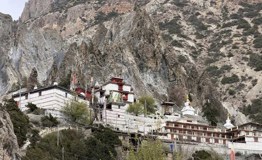
Older settlements such as Braga provide particularly atmospheric examples of traditional architecture, with stone houses appearing to rise directly from the mountainside.
Manang and the Annapurna Circuit Trek
Manang is one of the most important overnight stops on the Annapurna Circuit Trek.
Most well-paced itineraries spend two nights in Manang, providing one full day for acclimatization before continuing higher.
A common sequence is:
| Location | Approx. Altitude |
|---|---|
| Chame | 2,670 m |
| Upper Pisang | 3,300 m |
| Ngawal | Approx. 3,660 m |
| Braga | Approx. 3,450 m |
| Manang | Approx. 3,540 m |
| Yak Kharka | Approx. 4,050 m |
| Thorong Phedi | Approx. 4,540 m |
| Thorong La | 5,416 m |
| Muktinath | Approx. 3,760 m |
Why Spend an Acclimatization Day in Manang?
An acclimatization day in Manang is one of the most important parts of a safe and comfortable Annapurna Circuit itinerary.
Rather than remaining completely inactive, trekkers can use the day for a controlled hike to a higher elevation before returning to sleep in Manang. This follows the familiar high-altitude principle of “climb high, sleep low.”
Good acclimatization options include:
- Gangapurna Lake
- Chongkor Viewpoint
- Praken Gompa
- Ice Lake for stronger and already well-acclimatized trekkers
- Exploring Braga and its monastery
The appropriate hike depends on your health, energy level, previous altitude exposure and weather conditions. Acclimatization should never become a competition to reach the highest possible point.
Altitude Sickness in Manang
Because Manang lies above 3,500 metres, travellers need to be aware of Acute Mountain Sickness (AMS).
Possible symptoms can include:
- Headache
- Nausea
- Dizziness
- Unusual fatigue
- Loss of appetite
- Difficulty sleeping
Symptoms should never be ignored. Anyone experiencing worsening symptoms should inform their guide immediately and should not continue ascending until the situation has been properly assessed.
Severe altitude illness can become life-threatening and may require immediate descent and medical assistance.
Himalayan Rescue Association in Manang
Manang is known for the seasonal medical support and altitude-awareness services associated with the Himalayan Rescue Association (HRA). During trekking seasons, altitude information sessions have traditionally been an important resource for trekkers preparing to travel higher.
Operating schedules and services can vary, so travellers should check locally rather than assuming that a particular service or talk will operate every day.
Best Things to Do in Manang
A rest day in Manang does not mean there is nothing to do. The valley offers some of the best side trips on the Annapurna Circuit.
1. Visit Gangapurna Lake
Gangapurna Lake is one of Manang's most recognizable natural attractions. The glacial lake lies close to the village beneath Gangapurna Glacier.
The relatively short walk makes it a good option for travellers who want gentle activity during an acclimatization day without committing to a strenuous high-altitude hike.
2. See Gangapurna Glacier
The huge glacier descending from the mountains above Manang is one of the area's defining landscape features.
Views of the glacier, lake and surrounding peaks provide excellent opportunities for landscape photography.
3. Hike to Chongkor Viewpoint
Chongkor Viewpoint, sometimes spelled Chhonkar or Chongkor, provides panoramic views over Manang village, Gangapurna Lake and the surrounding mountains.
The hike offers more elevation gain than simply walking to the lake and can therefore form part of an acclimatization day for trekkers who do not want to undertake the much harder Ice Lake hike.
4. Hike to Ice Lake – Kicho Tal
Ice Lake, also known as Kicho Tal, is one of the most famous day hikes from the Manang and Braga area.
The lake lies at approximately 4,600 metres, meaning trekkers gain around 1,000 metres of elevation before descending again.
It is a strenuous full-day hike and should only be attempted when weather, trail conditions, fitness and acclimatization are appropriate.
From the upper slopes and lake area, trekkers can enjoy outstanding views toward Annapurna II, Annapurna III, Annapurna IV, Gangapurna, Tilicho Peak and the Chulu range.
5. Visit Praken Gompa
Praken Gompa is located above Manang and provides a combination of cultural interest, mountain scenery and useful altitude gain.
For many trekkers, it offers a good middle option between a gentle Gangapurna walk and the demanding Ice Lake hike.
6. Explore Manang Village
Allow time simply to walk through Manang. Observe traditional houses, prayer wheels, chortens, local shops, bakeries and daily village life.
After several days of trekking, Manang is also a useful place to rest, wash clothes, recharge equipment and prepare for the more remote section ahead.
7. Visit Braga Village
Braga, also written Bhraga or Braka, lies a short walk east of Manang and is one of the most atmospheric settlements in the valley.
Its traditional stone houses rise beneath a dramatic cliff, while its historic monastery is one of the cultural highlights of the Annapurna Circuit.
8. Visit Braga Monastery
Braga Monastery is an important Buddhist monastery in the Manang Valley. Its location above the old village, together with religious artwork and mountain surroundings, makes it well worth visiting.
Visitors should respect opening times and local rules concerning photography and sacred objects.
9. Explore Milarepa Cave
The Manang region is associated with the great Tibetan Buddhist yogi and poet Milarepa. A cave in the wider Braga area is traditionally connected with his meditation and forms an interesting cultural and spiritual side excursion.
The walk also provides useful altitude exposure for appropriately acclimatized trekkers.
10. Enjoy Himalayan Photography
Manang is outstanding for photography. Subjects include:
- Annapurna II, III and IV
- Gangapurna
- Gangapurna Glacier
- Gangapurna Lake
- Traditional villages
- Buddhist monasteries
- Prayer flags and chortens
- Dry Himalayan landscapes
- Sunrise and sunset light
Ice Lake Manang: Is It Worth the Hike?
For strong and properly acclimatized trekkers, the Ice Lake hike can be one of the highlights of the Annapurna Circuit.
| Local Name | Kicho Tal / Ice Lake |
| Altitude | Approximately 4,600 m |
| Starting Area | Manang / Braga |
| Difficulty | Strenuous |
| Main Purpose | Acclimatization and mountain views |
| Recommended | Only when properly acclimatized and conditions are suitable |
The substantial elevation gain makes this a serious high-altitude hike. Start early, walk slowly, carry sufficient water and layers, and turn around if altitude symptoms or poor weather develop.
Gangapurna Lake vs Ice Lake
| Gangapurna Lake | Ice Lake |
|---|---|
| Close to Manang | High above Manang/Braga |
| Shorter walk | Full-day hike |
| Gentler activity | Strenuous |
| Good for an easier acclimatization day | Significant altitude gain |
| Glacier views | Extensive Himalayan panorama |
Neither is automatically “better.” The right choice depends on how your body feels and what level of activity is appropriate for your acclimatization day.
Manang to Tilicho Lake
Manang is also a major gateway for trekkers planning a side trip to Tilicho Lake, situated at approximately 4,919 metres.
Instead of continuing directly toward Yak Kharka, trekkers can divert toward the Tilicho route, usually travelling through the Khangsar area toward Tilicho Base Camp before hiking to the lake.
After completing the Tilicho side trip, trekkers can reconnect with the Annapurna Circuit and continue toward Thorong La.
This extension adds additional trekking days and considerably more high-altitude exposure, so it should be incorporated carefully into the overall acclimatization plan.
Tilicho Lake: One of Manang's Great Side Adventures
Tilicho Lake is one of Nepal's most famous high-altitude lakes. Surrounded by an extraordinary wall of mountains and barren alpine terrain, it is a major objective for trekkers wanting to extend the Annapurna Circuit.
The route should not be treated as a casual excursion from Manang. It requires additional nights, careful acclimatization and attention to trail and weather conditions.
Manang to Thorong La Pass
After acclimatizing in Manang, most Annapurna Circuit trekkers continue toward:
Manang → Yak Kharka → Thorong Phedi / High Camp → Thorong La Pass → Muktinath
Thorong La stands at 5,416 metres (17,769 ft) and is the highest point of the classic Annapurna Circuit.
The crossing is physically demanding because of the altitude, cold, long walking day and potentially changing mountain weather.
A sensible acclimatization schedule before reaching the pass is therefore far more important than trying to complete the route quickly.
Manang to Yak Kharka
After Manang, the main Annapurna Circuit trail climbs gradually toward Yak Kharka, at approximately 4,050 metres.
The landscape becomes increasingly alpine and vegetation becomes sparse. Trekkers should maintain a slow, steady pace as sleeping altitude increases.
Manang to Thorong Phedi
From Yak Kharka, the trail continues toward Thorong Phedi, the principal staging point beneath Thorong La.
Some trekkers stay higher at High Camp, but the choice should depend on acclimatization, weather, individual condition and the advice of an experienced guide.
Thorong La Pass – 5,416 m
Crossing Thorong La is the defining high-altitude challenge of the Annapurna Circuit.
Trekkers normally start very early in the morning and climb gradually to the prayer-flag-covered pass before descending toward Muktinath in Mustang.
Weather conditions can change rapidly, and snow can make the crossing more difficult. Proper equipment, acclimatization and local guidance are essential.
Manang to Muktinath
After crossing Thorong La, the trail descends into Mustang toward Muktinath, one of Nepal's most important pilgrimage destinations for both Hindus and Buddhists.
The contrast between Manang and Mustang is one of the great experiences of the Annapurna Circuit, linking two distinct high-Himalayan valleys through Thorong La.
How to Get to Manang
There are two main ways to reach Manang: trekking as part of the Annapurna Circuit or travelling much of the route by road.
There is currently no regular commercial passenger flight directly from Kathmandu or Pokhara to Manang village.
Kathmandu to Manang
The traditional approach from Kathmandu is:
Kathmandu → Besisahar → Dharapani → Chame → Pisang → Manang
Travellers can reach Besisahar by road and then continue into the Marsyangdi Valley.
Road development now extends far into Manang District, but conditions vary considerably and can be affected by rain, landslides, snow, maintenance and construction.
Kathmandu to Besisahar
Besisahar is the traditional gateway to the Annapurna Circuit and the road journey into Manang.
From Kathmandu, travellers drive west toward the central hills before reaching Besisahar in Lamjung District.
Journey times vary depending on traffic and road conditions, so itineraries should avoid relying on overly precise driving times.
Besisahar to Manang by Jeep
It is possible to travel far into the Manang Valley by 4WD jeep. The rough mountain road follows the Marsyangdi corridor through settlements such as Dharapani and Chame before continuing toward the upper valley.
However, driving rapidly from low elevation directly to Manang can result in a very fast altitude gain. Travellers should therefore consider acclimatization rather than choosing an itinerary based only on the shortest driving time.
Chame to Manang
Chame, the administrative headquarters of Manang District, is one of the principal staging points on the eastern side of the Annapurna Circuit.
From Chame, the trekking route continues toward Bhratang, Dhukur Pokhari and Pisang before eventually reaching Manang.
Pisang to Manang: Lower Route or Upper Route?
Trekkers generally have two broad route choices between Pisang and Manang.
Lower Route
The lower route is generally easier and follows the valley more directly through Humde and Braga toward Manang.
Upper Route via Ghyaru and Ngawal
The higher route climbs through Ghyaru and Ngawal and provides spectacular views across the valley toward the Annapurna range.
Although more demanding, the additional altitude exposure can also contribute to acclimatization when approached sensibly.
For fit trekkers with suitable conditions, Himalayan Dream Team generally prefers the scenic high route because of its mountain views and cultural interest.
Ngawal Village
Ngawal is a beautiful traditional village located above the main Marsyangdi Valley. Its higher position provides outstanding views toward Annapurna II, Annapurna III, Gangapurna and surrounding peaks.
The village's traditional architecture, monastery and quiet atmosphere make it one of the cultural highlights on the approach to Manang.
Humde and Manang Airport
Humde lies east of Manang and has a small airstrip commonly known as Manang Airport.
Travellers should not plan an itinerary assuming regular commercial flights will be available. Road and trekking access remain the normal ways of reaching Manang.
Can You Drive Directly to Manang?
Road access has transformed travel through the Marsyangdi Valley, and vehicles can reach high into the Manang region when conditions allow.
However, the more important question is whether travelling directly to 3,500 metres is appropriate for your body.
A slower approach with intermediate nights is generally preferable because it allows more gradual acclimatization.
Best Time to Visit Manang Nepal
March to May – Spring
Spring is one of the best seasons for Manang and the Annapurna Circuit. Temperatures gradually become warmer, trails are active and mountain views can be excellent.
Higher areas may still contain snow early in the season.
June to August – Summer/Monsoon
Manang lies partly in the rain shadow of the Annapurna massif and can receive less rainfall than Nepal's southern hills.
However, the lower access roads and trails can still be affected by monsoon rain, landslides, swollen rivers and transportation delays.
September to November – Autumn
Autumn is another excellent period for Manang. Conditions are often stable, visibility is generally good and the season is especially popular for crossing Thorong La.
October is normally among the busiest trekking months.
December to February – Winter
Winter in Manang can be extremely cold. Snow and ice can affect high trails, and Thorong La may become dangerous or temporarily impassable during heavy snowfall.
Some lodges and services may operate on a reduced basis during the coldest months.
Manang Weather and Temperature
Manang has a cold, dry high-altitude climate. Even on sunny days, temperatures can fall rapidly after sunset.
Weather varies significantly by season and year, so travellers should prepare for:
- Strong sunshine
- Cold mornings and nights
- Strong afternoon winds
- Rapid temperature changes
- Snow at higher elevations
- Very cold conditions in winter
Layered clothing is essential.
How Many Days Should You Spend in Manang?
For Annapurna Circuit trekkers, Himalayan Dream Team recommends planning at least two nights in Manang: arrival day, one full acclimatization day and departure the following morning.
Some travellers benefit from an additional night, especially if they arrived quickly, are planning a strenuous side trip or need more time to acclimatize.
There is no advantage in rushing if your body needs more time.
Accommodation in Manang
Manang has a relatively good selection of trekking lodges and teahouses compared with smaller settlements higher on the circuit.
Facilities vary, but travellers may find:
- Private rooms
- Shared or attached bathrooms depending on the lodge
- Dining rooms
- Hot showers
- Charging facilities
- Wi-Fi
- Blankets
- Local and international-style meals
Hot water, charging and internet may involve additional fees.
Food in Manang
Manang has a wider range of food than many smaller high-altitude settlements.
Typical choices can include:
- Dal bhat
- Momos
- Thukpa
- Noodle soup
- Fried rice
- Potatoes
- Egg dishes
- Pasta
- Pizza
- Soups
- Bakery items
- Tea and coffee
At altitude, maintaining sufficient food and fluid intake is important even when appetite decreases.
Bakeries in Manang
One of the pleasant surprises for Annapurna Circuit trekkers is the presence of bakeries in Manang. After several days on the trail, fresh bakery items, coffee and warm indoor spaces can feel particularly welcome.
Manang is therefore a good place to relax and refuel before entering the higher and more remote section of the trek.
Drinking Water in Manang
Trekkers should carry a reusable water bottle and use safe drinking water throughout the journey.
Depending on your lodge and route, boiled, filtered or treated water may be available. Avoid creating unnecessary plastic waste by repeatedly purchasing disposable bottles.
Electricity and Charging
Charging is available at many lodges in Manang, although reliability and fees vary.
A power bank is strongly recommended, especially for travellers using phones for photography, navigation or communication.
Wi-Fi and Mobile Network in Manang
Internet and mobile connectivity have improved in the Annapurna region, but service in Manang can still be slower or less reliable than in Kathmandu or Pokhara.
Weather, electricity and local infrastructure can affect connections, so travellers should keep important information available offline.
ATM and Money in Manang
Financial services in remote mountain areas should never be treated as guaranteed.
Carry sufficient Nepalese rupees for accommodation extras, drinks, snacks, charging, showers, tips and personal purchases before travelling deep into the mountains.
Do not rely entirely on cards, digital payments or a single ATM.
Shopping and Trekking Supplies
Manang is one of the last substantial places to purchase basic trekking supplies before continuing toward Thorong La.
Depending on availability, shops may sell snacks, toiletries, gloves, hats, walking equipment and other essentials.
However, it is better to arrive properly equipped rather than depending on finding a particular item or brand in Manang.
Permits for Manang and the Annapurna Circuit
Manang lies within the Annapurna Conservation Area. International trekkers need to follow Nepal's current trekking and conservation-area permit regulations.
Permit and guide requirements can change, so travellers should verify current regulations when booking rather than relying on older blogs.
For guests travelling with Himalayan Dream Team, we arrange the required trekking permit formalities applicable to the chosen itinerary.
Do You Need a Guide for Manang?
Nepal's trekking regulations and requirements have changed over time, and the rules applicable to particular routes and nationalities should be checked before travel.
Beyond regulations, an experienced guide provides practical advantages in Manang and the high Annapurna region, including route selection, weather assessment, altitude monitoring, accommodation coordination and decision-making around Thorong La.
Manang Packing List
- Comfortable trekking boots
- Moisture-wicking base layers
- Warm mid-layer
- Down or insulated jacket
- Waterproof/windproof outer shell
- Trekking trousers
- Warm hat
- Sun hat
- Gloves
- UV-protection sunglasses
- High-SPF sunscreen
- Lip balm
- Trekking poles
- Reusable water bottle
- Water purification method
- Headlamp
- Power bank
- Personal medications
- Basic first-aid supplies
- Small daypack
- Sleeping bag suitable for the season
Responsible Travel in Manang
Manang's environment is beautiful but fragile. Every traveller can help protect it.
- Use refillable water bottles
- Minimize single-use plastics
- Carry waste responsibly
- Stay on established trails
- Do not disturb wildlife
- Ask permission before photographing people
- Respect monasteries and religious sites
- Do not touch ancient paintings or religious objects
- Support locally operated lodges and businesses
- Use water and electricity carefully
- Follow your guide's advice concerning local customs
Manang vs Mustang: Are They the Same?
No. Manang and Mustang are different districts and Himalayan regions, although both lie north of major Himalayan ranges and share some similarities in their dry landscapes and Tibetan Buddhist cultural influences.
The Annapurna Circuit famously connects the two: trekkers travel through Manang, cross Thorong La Pass and descend into Mustang toward Muktinath.
This transition between Manang and Mustang is one of the reasons the Annapurna Circuit is such a geographically and culturally diverse trek.
Manang vs Upper Mustang
| Manang | Upper Mustang |
|---|---|
| Part of the Annapurna Circuit | Historic Kingdom of Lo region |
| Main hub: Manang village | Main historic centre: Lo Manthang |
| Gateway to Thorong La | Known for Lo Manthang and cave culture |
| Gangapurna and Ice Lake | Desert cliffs and Chhoser caves |
| Access from Besisahar/Chame | Common access via Jomsom/Kagbeni |
| Standard Annapurna trekking regulations apply | Restricted-area permit regulations apply |
Is Manang Worth Visiting?
Manang is absolutely worth allowing time for on an Annapurna journey. The attraction is not simply the village itself but the combination of mountain scenery, Buddhist culture, glaciers, high-altitude lakes, traditional settlements and exceptional day hikes.
For Annapurna Circuit trekkers, the extra day also has a practical purpose: acclimatization before travelling into substantially higher terrain.
Frequently Asked Questions About Manang Nepal
1. Where is Manang in Nepal?
Manang is located in Manang District of Gandaki Province in north-central Nepal. The famous Manang village lies in the upper Marsyangdi Valley on the Annapurna Circuit.
2. What is the altitude of Manang?
Manang village is approximately 3,540 metres (11,614 ft) above sea level, although different maps may show slightly different elevations.
3. Why is Manang famous?
Manang is famous as the main acclimatization stop on the Annapurna Circuit and for Gangapurna Lake, Ice Lake, Buddhist monasteries, mountain scenery and access toward Tilicho Lake and Thorong La.
4. Is Manang part of the Annapurna Circuit?
Yes. Manang is one of the most important settlements on the classic Annapurna Circuit Trek.
5. How many days should I stay in Manang?
Most Annapurna Circuit trekkers should plan at least two nights, allowing one full acclimatization day before continuing higher.
6. Why do trekkers acclimatize in Manang?
Manang is located above 3,500 metres and provides convenient day hikes to higher elevations before the trail climbs toward Yak Kharka, Thorong Phedi and Thorong La.
7. What can I do during an acclimatization day in Manang?
You can hike toward Gangapurna Lake, Chongkor Viewpoint, Praken Gompa or Ice Lake, explore Manang village, visit Braga Monastery or simply take additional rest if needed.
8. How high is Ice Lake in Manang?
Ice Lake, or Kicho Tal, lies at approximately 4,600 metres.
9. How high is Gangapurna Lake?
Gangapurna Lake lies close to Manang at roughly the same general elevation as the village, with nearby viewpoints providing additional altitude gain.
10. How high is Tilicho Lake?
Tilicho Lake is situated at approximately 4,919 metres.
11. How high is Thorong La?
Thorong La Pass is 5,416 metres (17,769 ft) above sea level.
12. Can I drive from Kathmandu to Manang?
Road access extends far into the Manang Valley, but the journey is long and conditions vary. Rapidly driving from low elevation to Manang also requires careful consideration of altitude acclimatization.
13. Can I drive from Besisahar to Manang?
Vehicles can travel far into Manang District when road conditions permit. A suitable 4WD and experienced local driver are recommended for rough mountain sections.
14. Is there an airport in Manang?
There is an airstrip at Humde in Manang District, but travellers should not plan their trip around regular scheduled passenger flights. Road and trekking access are the normal options.
15. What is the best time to visit Manang?
Spring from March to May and autumn from September to November are generally the most popular periods for trekking in Manang.
16. Does it snow in Manang?
Yes. Snow is possible, particularly during winter and at higher elevations around the valley.
17. Is Manang very cold?
It can be. Nights are cold at this altitude even during popular trekking seasons, while winter temperatures can be severe.
18. Can beginners visit Manang?
Yes, provided they are reasonably fit, follow an appropriate itinerary and take altitude seriously. Reaching Manang does not require technical climbing.
19. Is Manang suitable for older trekkers?
Age alone does not determine suitability. Fitness, medical history, acclimatization, walking ability and itinerary pace are more important. Anyone with health concerns should seek medical advice before high-altitude travel.
20. Is Manang the same as Mustang?
No. They are different Himalayan districts. The Annapurna Circuit connects them by crossing Thorong La from Manang into Mustang.
21. Is Manang before or after Thorong La?
On the classic anticlockwise Annapurna Circuit, Manang comes before Thorong La.
22. What comes after Manang on the Annapurna Circuit?
The usual route continues from Manang toward Yak Kharka, Thorong Phedi or High Camp, Thorong La and Muktinath.
23. Can I visit Tilicho Lake from Manang?
Yes. Manang is a major gateway for the Tilicho Lake side trek. Several additional trekking days are required.
24. Is Ice Lake difficult?
Yes. The hike is strenuous because it climbs to around 4,600 metres and involves substantial elevation gain. It should only be attempted when properly acclimatized and in suitable conditions.
25. Are there hotels in Manang?
Yes. Manang has numerous trekking lodges and teahouses offering accommodation, meals and varying levels of facilities.
26. Is there Wi-Fi in Manang?
Wi-Fi and mobile connectivity may be available, but service can be unreliable compared with Nepal's cities.
27. Is there an ATM in Manang?
Financial facilities should not be relied upon in remote mountain areas. Carry sufficient Nepalese rupees before entering the high Himalayas.
28. Do I need a permit to visit Manang?
Manang lies within the Annapurna Conservation Area, and international trekkers must follow the current conservation-area and trekking permit requirements applicable at the time of travel.
29. Can I visit Manang without crossing Thorong La?
Yes. It is possible to visit Manang and return along the Marsyangdi Valley without crossing Thorong La. This can be suitable for travellers primarily interested in Manang Valley, culture and mountain scenery.
30. Is Manang good for photography?
Yes. Manang is one of the Annapurna region's finest photography destinations, with glaciers, lakes, Buddhist villages and panoramic views of the Annapurna Himalayas.
Explore Manang and the Annapurna Circuit with Himalayan Dream Team
Manang is much more than an acclimatization stop. It is one of the places where the Annapurna Circuit reveals its true Himalayan character.
By the time you reach Manang, the green valleys of lower Nepal have given way to dry mountain landscapes, glaciers and enormous snow-covered peaks. Ancient villages such as Braga and Ngawal reveal the cultural history of the valley, while Gangapurna Lake, Ice Lake and nearby viewpoints provide unforgettable opportunities to explore the landscape on foot.
Most importantly, spending adequate time in Manang helps prepare trekkers for the higher journey toward Yak Kharka, Thorong Phedi and Thorong La Pass at 5,416 metres.
At Himalayan Dream Team Treks & Tours, we design our Annapurna itineraries with careful attention to acclimatization, realistic walking times, experienced guides and enough time to experience the villages and landscapes rather than simply rushing through them.
Travellers interested in Manang can explore our related Annapurna journeys:
Whether Manang is your destination or an important stage on the journey to Thorong La, it deserves time. Stay an extra day, walk above the village, visit its monasteries, watch the changing light over Gangapurna and allow your body to adapt naturally to the high Himalayas.
Plan your Manang and Annapurna Circuit journey with Himalayan Dream Team and experience one of Nepal's most spectacular high-altitude valleys at a safe and comfortable pace.