

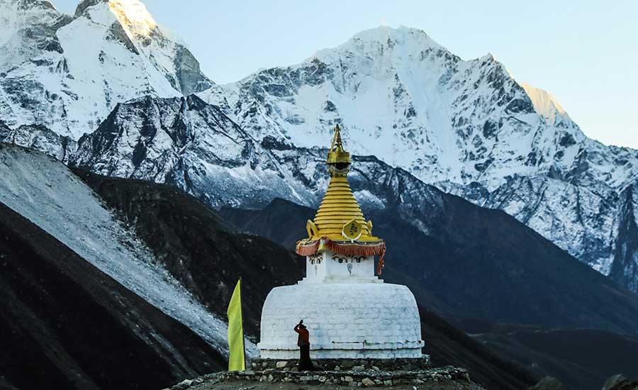
Dingboche Nepal: Complete Guide to the Everest Region’s Acclimatization Village
High in the Khumbu region of northeastern Nepal, Dingboche is one of the most important villages on the Everest Base Camp Trek. Situated at approximately 4,410 metres (14,470 ft), this high-altitude Sherpa settlement lies in the beautiful Imja Valley, surrounded by some of the most dramatic mountains in the Himalayas.
For most trekkers, Dingboche is much more than another overnight stop. It is normally the second major acclimatization point on the Everest Base Camp route after Namche Bazaar, giving the body valuable time to adjust before continuing towards Lobuche, Gorak Shep, Everest Base Camp and Kala Patthar.
Stone-walled fields spread across the valley, Ama Dablam dominates the skyline, and trails branch towards Chhukung, Island Peak and the upper Khumbu. Whether you are trekking to Everest Base Camp, climbing Island Peak or exploring the wider Everest region, Dingboche is one of those places where slowing down is an important part of the journey.
Dingboche at a Glance
| Dingboche Facts | Details |
|---|---|
| Location | Khumbu, Solukhumbu, Nepal |
| Elevation | Approx. 4,410 m / 14,470 ft |
| Region | Everest / Khumbu Region |
| Protected Area | Sagarmatha National Park |
| Main Trek | Everest Base Camp Trek |
| Main Purpose | Acclimatization and overnight stop |
| Previous Major Stop | Tengboche / Pangboche |
| Next Major Stop | Lobuche |
| Popular Acclimatization Hike | Nangkartshang Hill/Ridge |
| Nearby Side Trip | Chhukung Valley |
| Main Mountain Views | Ama Dablam, Lhotse, Island Peak, Taboche, Cholatse and surrounding peaks |
| Accommodation | Mountain lodges and teahouses |
| Best Trekking Seasons | Spring and autumn |
| Typical Stay | Usually 2 nights on a well-paced EBC itinerary |
Where Is Dingboche?
Dingboche lies in the Khumbu region of Solukhumbu District in northeastern Nepal, within the wider Sagarmatha National Park area. The village sits in the Imja Valley above the tree line, where the green forests of the lower Everest trail gradually give way to open alpine terrain, stone walls and glacial landscapes.
Most travellers reach Dingboche while trekking from Tengboche through Pangboche and Shomare. From Dingboche, the main Everest Base Camp trail continues towards Thukla and Lobuche, while another route turns east through the Imja Valley towards Chhukung and Island Peak.
This location makes Dingboche both an important trekking settlement and a natural junction for several adventures in the Everest region.
What Is the Altitude of Dingboche?
Dingboche is approximately 4,410 metres (14,470 ft) above sea level.
At this elevation, trekkers are well into the high-altitude environment. The air contains significantly less available oxygen than at sea level, so walking becomes slower, nights feel colder and proper acclimatization becomes increasingly important.
This is one reason Himalayan Dream Team itineraries do not treat Dingboche simply as a place to sleep. We normally use it as an active acclimatization stop before moving higher towards Lobuche and Everest Base Camp.
Why Is Dingboche Important on the Everest Base Camp Trek?
The journey from Lukla to Everest Base Camp involves a major increase in altitude:
| Location | Approx. Elevation |
|---|---|
| Lukla | 2,860 m |
| Phakding | 2,610 m |
| Namche Bazaar | 3,440 m |
| Tengboche | 3,860 m |
| Dingboche | 4,410 m |
| Lobuche | 4,910 m |
| Gorak Shep | 5,164 m |
| Everest Base Camp | 5,364 m |
| Kala Patthar | 5,545 m |
By the time trekkers arrive in Dingboche, they are sleeping almost 1,000 metres higher than Namche Bazaar. The following stages then remain at very high elevations.
For this reason, a properly designed Everest Base Camp itinerary normally includes an additional night in Dingboche rather than immediately continuing upwards.
The aim is simple: gain some elevation during the day, return to Dingboche to sleep, rest properly and allow the body more time to adapt before proceeding higher.
Acclimatization in Dingboche
Although it is commonly called a “rest day,” a Dingboche acclimatization day does not necessarily mean staying inside the lodge all day.
A gradual hike to a higher elevation followed by a descent to sleep lower can form part of the acclimatization process. The exact hike should always depend on weather, trail conditions and how each trekker is responding to altitude.
At Himalayan Dream Team, we prefer not to push everyone to a fixed height simply because it appears on an itinerary. Your guide observes how you are feeling and adjusts the day's activity accordingly.
Nangkartshang Hill Acclimatization Hike
The ridge above Dingboche, commonly referred to as Nangkartshang Hill or Nangkartshang Peak, is the best-known acclimatization hike from the village.
The trail climbs steadily above Dingboche and quickly opens onto wide views across the Imja Valley. Depending on your condition, weather and acclimatization, you may hike part of the ridge or continue higher.
On a clear day, the surrounding panorama can include Ama Dablam, Lhotse, Makalu, Island Peak, Taboche, Cholatse and the Imja Valley.
There is no need for every trekker to reach the highest point. For acclimatization, gaining useful elevation and returning safely to sleep in Dingboche is more important than treating the hike as a summit challenge.
Things to Do in Dingboche
Dingboche is primarily a trekking and acclimatization village, but there is plenty to experience during your stay.
1. Hike Above Dingboche
A gradual climb towards Nangkartshang Ridge is the classic activity on an acclimatization day. The higher you walk, the wider the Himalayan panorama becomes.
2. Explore Dingboche Village
Take an easy walk through the settlement and observe the traditional stone walls, mountain lodges, small shops, prayer flags and everyday life in this remote Himalayan valley.
3. Walk Towards Chhukung Valley
The trail east towards Chhukung follows the Imja Valley and offers a different perspective of the surrounding mountains. Chhukung, at approximately 4,730 m, is also an important base for trekkers and climbers heading towards Island Peak and Kongma La.
A longer excursion should only be undertaken when your acclimatization, available time and weather conditions are suitable.
4. Enjoy the Mountain Views
Dingboche is one of the most scenic overnight locations on the Everest Base Camp route. Ama Dablam is especially striking from this part of the trail, while Lhotse, Island Peak, Taboche, Cholatse and other Himalayan peaks dominate different parts of the horizon.
5. Rest and Recover
Acclimatization also requires recovery. Enjoy a warm meal, drink enough fluids, organize your equipment and give your legs time to recover before the higher stages of the trek.
6. Experience Sherpa Mountain Life
Although trekking tourism is now an important part of the local economy, Dingboche remains part of the cultural landscape of Khumbu. Stone buildings, Buddhist symbols, prayer flags, mani walls, farming traditions and yak-related livelihoods all form part of life in the region.
Dingboche to Chhukung
Chhukung (approximately 4,730 m) lies east of Dingboche in the upper Imja Valley.
The route is especially important for people undertaking Island Peak climbing, the Everest Three Passes Trek or exploring the Chhukung Valley. It can also be used as an acclimatization excursion by appropriately acclimatized trekkers.
From Chhukung, experienced trekkers may continue towards Chhukung Ri, Island Peak Base Camp or Kongma La depending on their itinerary.
These should not be confused with a simple village walk from Dingboche. They involve greater altitude and physical effort and should be approached according to acclimatization and conditions.
Dingboche to Lobuche
After completing the acclimatization day, most Everest Base Camp trekkers continue from Dingboche to Lobuche, at approximately 4,910 m.
The route climbs gradually above the valley towards Thukla/Dughla. From there, a steeper ascent reaches the Thukla memorial area, where stone memorials honour climbers and Sherpas who lost their lives in the Everest region.
The trail then continues through increasingly barren high-altitude terrain towards Lobuche.
For many trekkers, this stage makes the value of the extra night in Dingboche very clear: from here onwards, the trek remains close to or above 5,000 metres.
How to Reach Dingboche
There is no normal road access to Dingboche. Most visitors arrive on foot as part of a trek through the Everest region.
A typical approach is:
Kathmandu → Lukla → Phakding → Namche Bazaar → Tengboche → Pangboche → Dingboche
Most Everest trekkers first travel to Lukla, the traditional gateway to the Khumbu trekking region, and then gradually walk higher through the Dudh Koshi and Khumbu valleys.
A properly paced journey includes acclimatization before Dingboche, particularly around Namche Bazaar, rather than trying to reach 4,410 m as quickly as possible.
Tengboche to Dingboche
The trekking stage from Tengboche to Dingboche normally takes around 5–7 hours, depending on pace, weather, trail conditions and acclimatization.
After leaving Tengboche, the trail descends through Deboche before continuing towards Pangboche. From here, trekkers pass through settlements such as Shomare and follow the Imja Valley higher.
Vegetation gradually becomes thinner as the route moves above 4,000 metres. The landscape becomes more open and alpine before the final approach to Dingboche.
Dingboche Weather and Temperature
Weather in Dingboche can change quickly because of its elevation and exposed Himalayan location.
Even during the main trekking seasons, mornings may begin clear while cloud or wind develops later in the day. Nights are cold, and temperatures can fall below freezing, particularly outside the warmer trekking months.
Rather than relying on one fixed temperature table, trekkers should prepare for strong sunshine, cold wind, freezing nights and rapid weather changes.
Warm layers, a windproof outer layer, gloves, a warm hat, good trekking footwear and a suitable sleeping bag become increasingly important at and above Dingboche.
Best Time to Visit Dingboche
The most popular periods for trekking through Dingboche are spring (March to May) and autumn (September to November).
Spring: March to May
Spring is one of the main Everest trekking seasons. Days gradually become warmer, and April and May also coincide with the major Everest climbing season.
Autumn: September to November
Autumn is known for generally clear mountain views and is one of the busiest periods on the Everest Base Camp trail. October and November are particularly popular.
Winter: December to February
Winter trekking is possible for experienced and properly equipped trekkers, but conditions are considerably colder. Snowfall can affect trails and high passes.
Monsoon: June to August
The Everest region receives less monsoon rainfall than some lower parts of Nepal, but cloud, rain, wet trails and flight disruption can still affect travel. Mountain visibility can also be more limited.
Mountain weather is never guaranteed in any season, so flexibility remains important.
Accommodation in Dingboche
Dingboche has a good selection of teahouses and mountain lodges catering to Everest trekkers.
Accommodation is generally simple compared with city hotels, although standards vary between lodges. Rooms normally provide beds, mattresses, blankets and pillows, while dining rooms serve as the main warm communal area.
Depending on the lodge, additional services may include:
Charging facilities
Wi-Fi or mobile connectivity
Hot showers
Bottled or boiled drinking water
Snacks and drinks
Most extra services cost more at higher elevations because supplies have to be transported into the mountains.
During the busiest spring and autumn trekking periods, advance arrangements are useful, particularly for larger groups.
Food in Dingboche
Despite its remote location, lodges in Dingboche normally offer a surprisingly varied menu.
Typical choices may include dal bhat, soups, noodles, fried rice, potatoes, pasta, eggs, momos, porridge, pancakes, Tibetan bread and hot drinks.
At high altitude, appetite can sometimes decrease, but eating sufficiently remains important. Warm, simple and carbohydrate-rich meals are often practical choices during the trek.
Prices generally increase as you travel higher into the Everest region because most supplies must be carried or transported over considerable distances.
Drinking Water in Dingboche
Safe hydration is particularly important at altitude.
Trekkers can normally obtain boiled water at lodges or treat available water using an appropriate purification method. Buying repeated single-use plastic bottles creates unnecessary waste, so carrying a reusable bottle is preferable.
Drink regularly throughout the day, but remember that drinking excessive quantities of water does not prevent altitude sickness. Gradual ascent and proper acclimatization remain the key factors.
Wi-Fi, Electricity and Mobile Network
Dingboche is remote, but trekkers may still find access to Wi-Fi, charging and limited mobile connectivity, depending on the lodge, provider and current conditions.
These services should never be considered guaranteed. Weather, power availability and technical problems can interrupt connections.
Charging and internet access may also carry additional fees, so carrying a power bank is useful.
Altitude Sickness in Dingboche
At 4,410 m, altitude illness must be taken seriously.
Possible symptoms of Acute Mountain Sickness (AMS) include headache, nausea, dizziness, unusual fatigue and loss of appetite. Symptoms vary from person to person, and physical fitness does not make someone immune to altitude illness.
A key rule is simple: do not continue to a higher sleeping altitude when symptoms of altitude illness are present.
If symptoms become worse despite resting at the same elevation, descent may be necessary. Serious conditions such as High-Altitude Cerebral Edema (HACE) and High-Altitude Pulmonary Edema (HAPE) require urgent action and descent.
This is one of the reasons Himalayan Dream Team places great importance on gradual ascent, acclimatization days and experienced trekking guides.
Dingboche or Pheriche: What Is the Difference?
Dingboche and Pheriche are neighbouring high-altitude settlements that are sometimes confused by first-time Everest trekkers.
Dingboche lies in the Imja Valley and is commonly used as the main acclimatization stop on the ascent towards Everest Base Camp. It also provides access towards Chhukung and Island Peak.
Pheriche, at a slightly lower elevation, lies in the neighbouring valley. Many EBC itineraries pass through or stay in Pheriche on the descent.
Both villages are important points on the Everest trekking network, but their positions make them useful for different itinerary stages.
Mountains Seen from Dingboche
One of the great rewards of staying in Dingboche is the surrounding Himalayan scenery.
Depending on your position, weather and visibility, prominent peaks in the wider panorama include:
| Mountain | Elevation |
|---|---|
| Lhotse | 8,516 m |
| Makalu | 8,485 m |
| Ama Dablam | 6,812 m |
| Island Peak / Imja Tse | 6,189 m |
| Cholatse | 6,440 m |
| Taboche | Approx. 6,367 m |
Ama Dablam is particularly prominent and gives the Dingboche landscape much of its distinctive character.
Everest itself is not necessarily the dominant mountain view from every point in Dingboche; the surrounding ridges and neighbouring giants shape the panorama.
Sherpa Culture and Life in Dingboche
Dingboche is not simply an acclimatization station created for trekkers. It forms part of the traditional Sherpa cultural landscape of the Khumbu.
For generations, people in this high-altitude region have adapted to a demanding environment through agriculture, livestock, trade and strong community traditions. The long stone walls surrounding fields are among Dingboche's most distinctive features and help protect cultivated land and define the landscape.
Today, trekking and mountaineering are important parts of the local economy. Lodges, guiding, porter services and other tourism-related businesses connect traditional mountain life with the thousands of international visitors who travel through the Everest region.
Visitors should treat monasteries, mani stones, prayer wheels and other Buddhist sites respectfully and follow the guidance of their local guide.
Permits Needed to Trek to Dingboche
Dingboche lies on the main Everest trekking route within the Sagarmatha National Park area.
International trekkers normally require:
Sagarmatha National Park Entry Permit – required for entering the protected national park.
Khumbu Pasang Lhamu Rural Municipality Entry Permit – required for trekking within the local Khumbu municipality.
Permit rules and fees can change, so they should always be checked before departure rather than relying on an old online article.
When trekking with Himalayan Dream Team, the required trekking permits and route arrangements are organized according to your itinerary.
What to Pack for Dingboche
By the time you reach Dingboche, you are trekking above 4,400 metres, so your equipment should be suitable for cold and changeable high-altitude conditions.
Important items include a warm down jacket, thermal base layers, fleece or insulated mid-layer, waterproof/windproof outer shell, warm trekking trousers, gloves, hat, UV-protection sunglasses, sunscreen, trekking poles, comfortable trekking boots, reusable water bottles and a suitable sleeping bag.
A headlamp and power bank are also useful.
The goal is not to carry unnecessary equipment but to have reliable layers that allow you to adjust as temperatures and wind change during the day.
How Long Should You Stay in Dingboche?
For a standard Everest Base Camp itinerary, two nights in Dingboche is a sensible pattern: arrive and sleep the first night, spend the following day acclimatizing, and sleep again at approximately the same elevation before continuing towards Lobuche.
Some trekkers may require additional time depending on their symptoms, previous altitude exposure, pace or overall itinerary.
Acclimatization cannot be rushed simply to stay on schedule.
Is Dingboche Worth Visiting?
Absolutely—but its importance goes beyond sightseeing.
Dingboche brings together several defining elements of trekking in the Everest region: high-altitude landscapes, Sherpa culture, spectacular Himalayan views and the need to respect the mountains rather than hurry through them.
For trekkers heading towards Everest Base Camp, the village represents an important transition. Below Dingboche, much of the route still passes through forests and permanent settlements. Above it, the environment becomes increasingly barren, glacial and demanding.
Taking an extra day here allows you not only to prepare physically for the altitude ahead but also to appreciate one of the most beautiful valleys in the Khumbu.
Trekking to Dingboche with Himalayan Dream Team
At Himalayan Dream Team, we believe a successful Everest trek is not about reaching each destination as quickly as possible.
Our Everest itineraries are designed around gradual altitude gain, appropriate acclimatization and realistic walking days. Dingboche is therefore an important part of the journey rather than simply another name on the itinerary.
Our local trekking team monitors the group's condition, weather and trail situation and adjusts the day's activity when necessary. On the acclimatization day, this may mean hiking higher on the Nangkartshang ridge, choosing a shorter walk or simply allowing additional recovery when that is the wiser option.
The mountains will always be there. Reaching them safely and enjoying the journey matters more than rushing.
Frequently Asked Questions About Dingboche
1. Where is Dingboche in Nepal?
Dingboche is a high-altitude Sherpa village in the Khumbu region of Solukhumbu, northeastern Nepal. It lies on the main trekking route towards Everest Base Camp.
2. What is the altitude of Dingboche?
Dingboche is situated at approximately 4,410 metres (14,470 ft) above sea level.
3. Why do trekkers stay in Dingboche?
Most Everest Base Camp trekkers stay in Dingboche for acclimatization before continuing towards Lobuche, Gorak Shep and Everest Base Camp.
4. How many nights should I stay in Dingboche?
A well-paced Everest Base Camp itinerary commonly spends two nights in Dingboche, including one acclimatization day.
5. What is the best acclimatization hike in Dingboche?
The hike towards Nangkartshang Hill/Ridge is the classic acclimatization walk. Trekkers can gain altitude during the day before descending to sleep again in Dingboche.
6. Do I need to reach the top of Nangkartshang Hill?
No. Acclimatization is not a summit competition. How high you hike should depend on your condition, weather and your guide's assessment.
7. How long does it take to trek from Tengboche to Dingboche?
Most trekkers take approximately 5–7 hours, although walking time varies with route, pace, weather and acclimatization.
8. How long does Dingboche to Lobuche take?
The trek normally takes approximately 5–6 hours, depending on walking speed, weather and trail conditions.
9. Can you see Mount Everest from Dingboche?
Dingboche has spectacular Himalayan views, although Everest itself is not always the dominant or clearly visible mountain from every location. Ama Dablam, Lhotse, Taboche, Cholatse and the Imja Valley are among the major features of the surrounding panorama.
10. What is the best time to visit Dingboche?
The main trekking seasons are March to May and September to November, with April–May and October–November especially popular.
11. Is there accommodation in Dingboche?
Yes. Dingboche has numerous mountain lodges and teahouses offering rooms, meals and, depending on the property, facilities such as charging, Wi-Fi and hot showers.
12. Is there Wi-Fi in Dingboche?
Wi-Fi may be available at some lodges, but connections can be slow or unavailable because of weather, power and network conditions.
13. Is there electricity in Dingboche?
Charging is generally available at many lodges for an additional fee, but availability should not be assumed. A power bank is recommended.
14. Is altitude sickness common in Dingboche?
Altitude symptoms can occur because Dingboche is above 4,400 m. Trekkers should ascend gradually, communicate symptoms to their guide and never continue higher when suffering from altitude illness.
15. Can I go from Dingboche to Chhukung?
Yes. Dingboche connects with the Imja Valley route to Chhukung. This route is used by trekkers and climbers heading towards Chhukung Ri, Island Peak and Kongma La.
16. Is Dingboche part of the Everest Base Camp Trek?
Yes. Dingboche is one of the principal overnight and acclimatization stops on the classic Everest Base Camp trekking route.
17. Which is higher, Dingboche or Namche Bazaar?
Dingboche, at approximately 4,410 m, is considerably higher than Namche Bazaar at approximately 3,440 m.
18. Which is higher, Dingboche or Lobuche?
Lobuche is higher. Dingboche is approximately 4,410 m, while Lobuche is around 4,910 m.
19. What permits do I need for Dingboche?
Everest-region trekkers normally require the Sagarmatha National Park Entry Permit and Khumbu Pasang Lhamu Rural Municipality Entry Permit. Current requirements should be confirmed before travelling.
20. Is Dingboche suitable for beginners?
A first-time Himalayan trekker can reach Dingboche as part of a properly paced Everest itinerary, provided they have suitable fitness, preparation and acclimatization. Previous high-altitude trekking experience is helpful but not always necessary.
Final Thoughts
Dingboche is one of the most important places on the Everest Base Camp Trek. At approximately 4,410 metres, it gives trekkers valuable time to acclimatize while offering exceptional views of Ama Dablam, Lhotse, Island Peak and the surrounding Khumbu Himalaya.
But perhaps Dingboche's greatest lesson is simple: high in the Himalayas, progressing well does not always mean moving forward every day.
Sometimes the smartest day of the trek is the one spent climbing a little higher, returning to the same village, eating a warm meal and giving your body another night to adjust.
That is why, for Himalayan Dream Team, Dingboche is not merely a stop before Everest Base Camp. It is an essential part of experiencing the Everest region safely, slowly and properly.